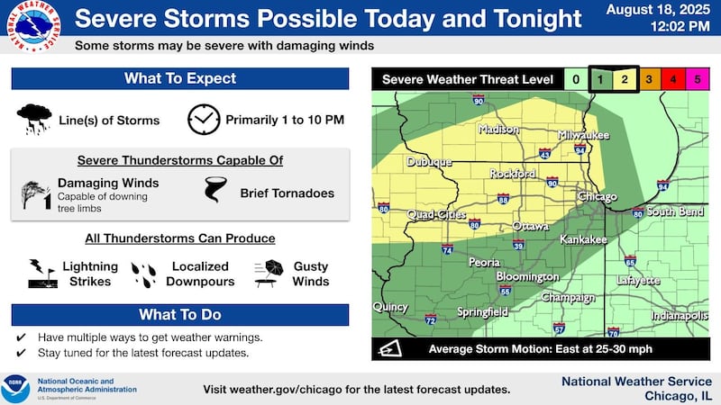
Severe thunderstorms with the risk for damaging winds and even tornadoes could hit northern Illinois on Monday afternoon and evening, the National Weather Service warned.
The following counties are under a severe thunderstorm watch until 6 p.m.: Boone, Bureau, Cook, DeKalb, DuPage, Grundy, Henry, Kane, Kendall, Lake, La Salle, Lee, McHenry, Ogle, Putnam, Whiteside, Will and Winnebago.
A severe thunderstorm warning was issued for Kirkland and Esmond, both in DeKalb County, until 4 p.m.
The possibility of hail – penny-sized to half-inch – was also reported as the storms moved west through McHenry County into DeKalb and Ogle counties, according to special weather statements posted to X, formerly known as Twitter.
Showers and storms are expected Monday afternoon and evening with a few that could be severe with damaging winds and torrential downpours, according to a hazardous weather outlook.
“With saturated soil conditions, even a brief period of intense rainfall could lead to a flash flooding situation,” the National Weather Service said.
Storms could bring wind gusts of up to 60 mph, heavy downpours and an isolated tornado risk.
Hot and humid conditions are also expected, with heat index values climbing near or above 100 degrees away from Lake Michigan, where the weather service issued a high swim risk through mid-afternoon, especially along Lake and northern Cook County shorelines.
Storms are expected to move east at about 25 mph and may linger into the evening. Spotters may be called on to report severe weather.
Looking ahead, the weather service said there is a limited chance of thunderstorms on Tuesday, mainly southeast of Interstate 55.
:quality(70)/s3.amazonaws.com/arc-authors/shawmedia/816e96b9-8582-47c5-84fd-a268095b4ce2.png)